Hiking is often romanticized as a peaceful communion with nature a simple walk through scenic trails with rewarding views at the end. But some of the world's most iconic hiking trails tell a very different story. These aren't your weekend nature walks. They're death defying journeys where one misstep can mean disaster, where the weather can turn lethal in minutes, and where even experienced mountaineers tread with extreme caution.
The world's deadliest hikes don't earn their reputation through folklore alone. They're backed by sobering statistics, documented accidents, and countless rescue operations. What separates a challenging trail from a truly dangerous one? It's not always about altitude or distance. Sometimes it's the lethal combination of unstable terrain, unpredictable weather, and sheer exposure that transforms an adventure into a survival situation.
Table of Contents
This isn't a list for beginners. If you're planning to tackle any of these trails, you'll need more than enthusiasm you'll need technical skills, proper equipment, physical conditioning, and most importantly, respect for the mountain. Each year, these trails claim lives, often from those who underestimated their difficulty or overestimated their abilities.
In this comprehensive guide, we'll explore the world's most dangerous hiking trails, examine what makes them so deadly, and provide crucial survival advice for those brave (or perhaps foolish) enough to attempt them. Consider this your reality check before you lace up those boots.
What Makes a Hike Deadly?
Before we dive into our countdown of the world's most dangerous trails, it's essential to understand that "dangerous" doesn't simply mean "difficult." A hike can be physically demanding without being life-threatening. True danger arises from a combination of factors that can overwhelm even prepared hikers.
The Fatal Five: Key Danger Factors
1. Extreme Exposure
Trails with narrow ridgelines, sheer cliff drops, and minimal protection from falls create situations where a single mistake is unforgivable. Unlike forest trails where you might tumble a few feet, exposed mountain paths mean falls of hundreds or even thousands of feet.
2. Unpredictable Weather
Mountains create their own weather systems. What starts as a sunny morning can turn into a deadly storm within hours. High winds can knock hikers off ridges, sudden temperature drops can cause hypothermia, and rain can transform solid rock into slick death traps.
3. Technical Terrain
Some trails require actual climbing skills, not just hiking. If you need to use chains, ladders, or navigate via ferrata routes, you're moving beyond traditional hiking into mountaineering territory. These sections demand upper body strength, balance, and often a head for heights.
4. Altitude and Oxygen Deprivation
Above 8,000 feet, altitude sickness becomes a real concern. Above 14,000 feet, you're in serious territory where your body struggles to function. The "death zone" above 26,000 feet isn't hyperbole your body is literally dying, cell by cell.
5. Remoteness and Rescue Difficulty
Some trails are so remote that if something goes wrong, rescue can take days if it comes at all. Without cell service, GPS signals, or nearby help, you're entirely dependent on your preparation and luck.
The Human Factor
Surprisingly, one of the biggest dangers on many deadly trails is other people. Popular dangerous trails can become overcrowded, leading to bottlenecks on narrow sections, depleted resources at camps, and a false sense of security from seeing others. Conversely, being completely alone on a remote trail means there's no one to help if you get injured.
Understanding these factors helps explain why our list includes everything from 8,000-meter Himalayan giants to a "small" mountain in New Hampshire. It's not just about height it's about the perfect storm of conditions that can turn any trail into a graveyard.
The World's 12 Deadliest Hikes
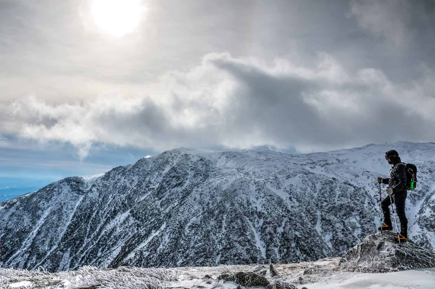
12. Mount Washington, New Hampshire, USA
Elevation: 1,916 meters (6,288 feet)
Death Toll: 150+ since 1849
Primary Hazards: Extreme weather, hypothermia, high winds
Don't let the modest elevation fool you Mount Washington has earned the nickname "Home of the World's Worst Weather" for good reason. This New Hampshire peak once recorded wind speeds of 372 km/h (231 mph), a world record that stood for over 60 years.
Why It's Deadly:
The combination of maritime weather systems and extreme latitude creates a meteorological nightmare. Temperatures can plummet to -50°C (-58°F), and weather conditions can shift from pleasant to lethal within minutes. The mountain attracts casual hikers who drastically underestimate its danger many wearing shorts and t-shirts only to face blizzard conditions hours later.
About 25 rescue operations are conducted annually, and the mountain claims several lives each year. Ironically, the presence of a cog railway to the summit gives tourists a false sense of safety, leading many to start hikes inadequately prepared.
Survival Tips:
- Check the Mount Washington Observatory weather forecast religiously
- Pack winter gear even in summer (waterproof layers, insulated jacket, hat, gloves)
- Turn back at the first sign of weather deterioration summit fever kills
- Start early; afternoon thunderstorms are common
- Know the signs of hypothermia: shivering, confusion, slurred speech
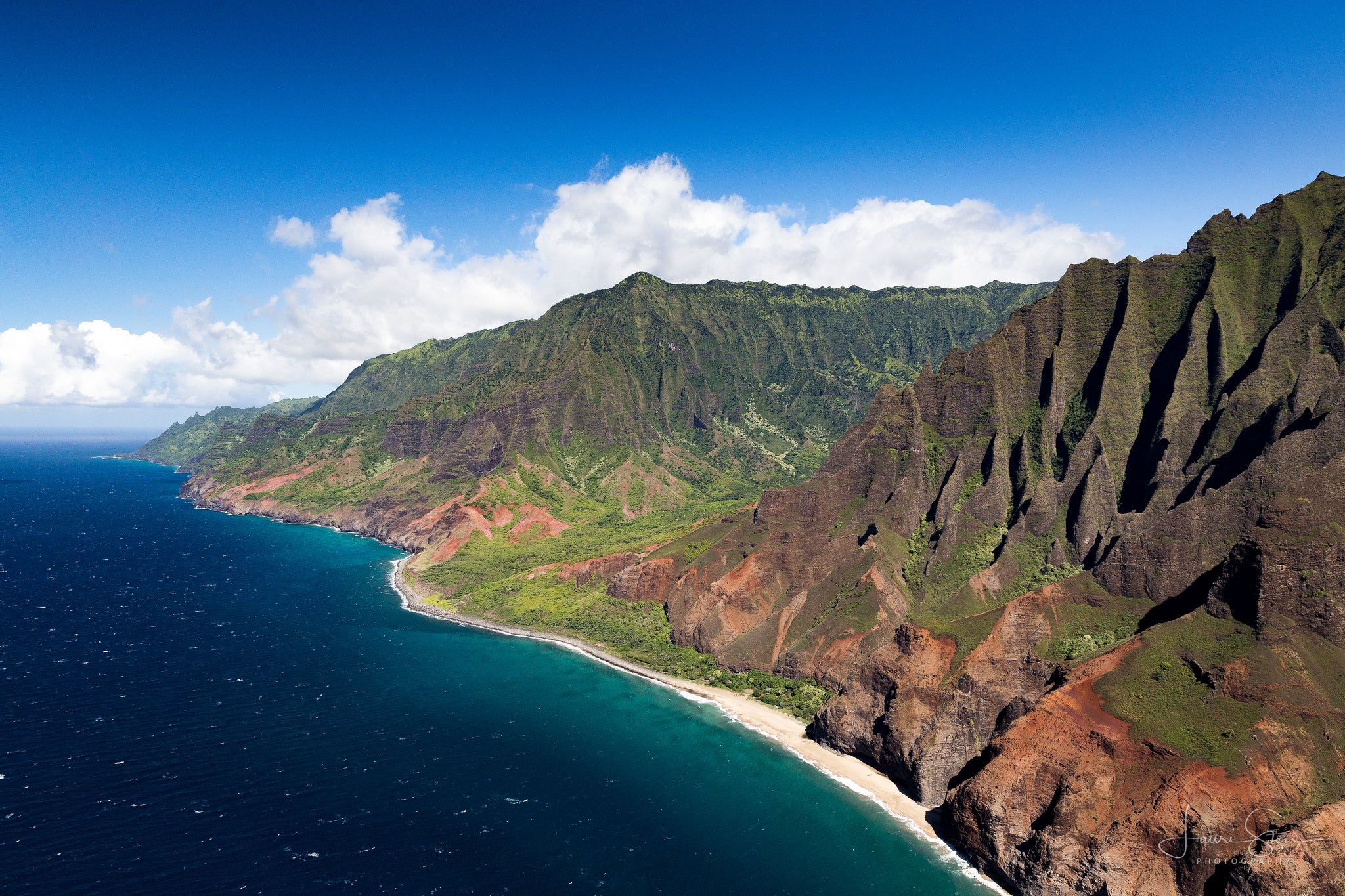
11. Kalalau Trail, Kauai, Hawaii, USA
Distance: 35 km (22 miles) round trip
Death Toll: Several deaths annually
Primary Hazards: Flash floods, stream crossings, coastal cliffs, rockfalls
Paradise has a dark side. The Kalalau Trail along Kauai's Na Pali Coast is stunningly beautiful and extraordinarily dangerous. This coastal trail features narrow paths carved into sheer cliffs, treacherous stream crossings that can turn deadly during flash floods, and terrain that becomes dangerously slippery with even light rain.
Why It's Deadly:
The trail's first two miles to Hanakapiai Beach are relatively easy, luring unprepared tourists further along. But beyond that point, the trail becomes increasingly technical and exposed. The Hanakapiai Stream has claimed numerous lives—several hikers have been swept out to sea while attempting crossings during high water.
The trail's popularity means it's often crowded, but that provides little safety. In fact, overcrowding on narrow cliff sections creates additional hazards. Additionally, many visitors underestimate the trail because they're in vacation mode, forgetting that this is serious backcountry terrain.
Survival Tips:
- Never cross streams when water is above knee level wait it out or turn back
- Wear proper hiking boots with aggressive tread; flip-flops and sandals are suicide
- Start your hike in early morning; afternoon rains are common
- Carry water treatment supplies; the streams are contaminated with leptospirosis
- Respect the ocean; rogue waves have pulled people from the beach
- Get a permit it's required and helps rangers track who's on the trail
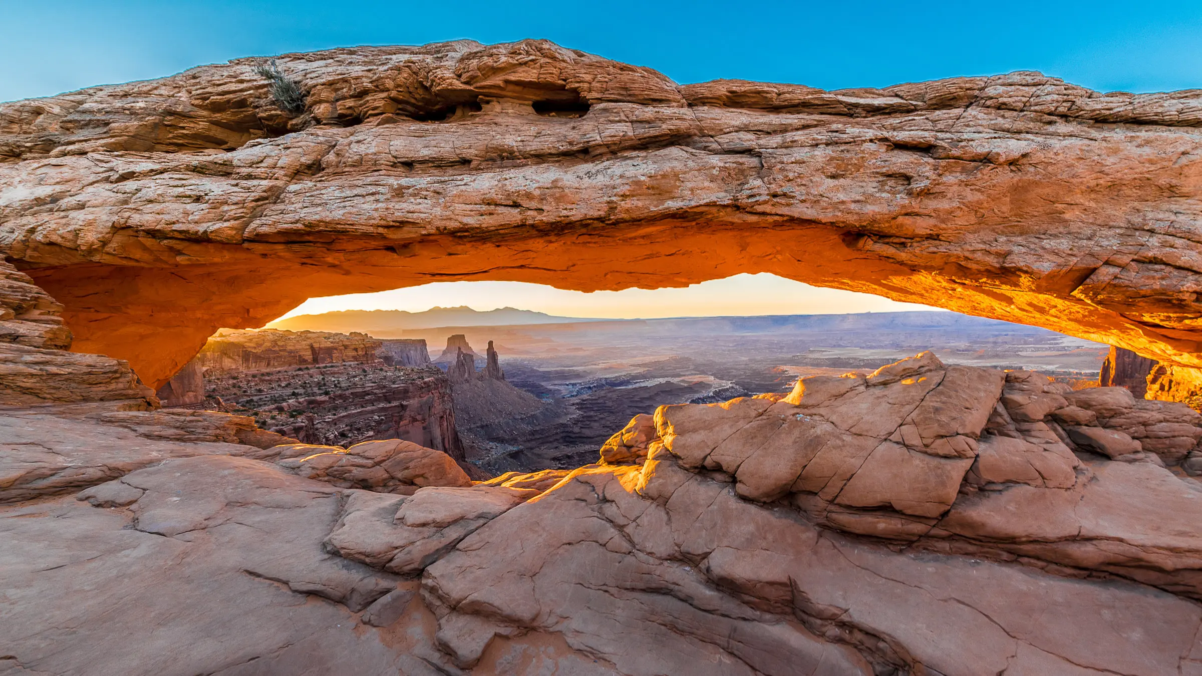
10. The Maze, Canyonlands National Park, Utah, USA
Area: 100+ square kilometers of canyon country
Death Toll: Multiple fatalities, numerous rescues
Primary Hazards: Extreme heat, dehydration, navigation difficulty, remoteness
The Maze isn't a single trail it's a vast, convoluted wilderness of canyons that lives up to its name. Located in one of the most remote areas of the continental United States, The Maze has been called the least accessible section of American parkland.
Why It's Deadly:
Summer temperatures regularly exceed 43°C (110°F), and there's virtually no shade. Water sources are scarce and unreliable. The canyon walls all look similar, making navigation extremely difficult even with maps and GPS. If you get lost or injured here, rescue can take days—assuming anyone even knows you're missing.
The Maze requires a high-clearance 4WD vehicle just to reach the trailheads, and even those roads are treacherous. Once you're in the canyons, you're utterly on your own. Cell service doesn't exist. Satellite communicators are mandatory, not optional.
Survival Tips:
- Carry at least twice the water you think you'll need (minimum 1 gallon per person per day)
- Never hike alone; groups of 3-4 are ideal
- Bring multiple navigation methods: maps, compass, GPS, and know how to use them
- Notify park rangers of your exact route and expected return
- Carry a satellite messenger device
- Avoid summer months; hike in spring or fall
- Pack electrolyte supplements; water alone won't prevent heat exhaustion
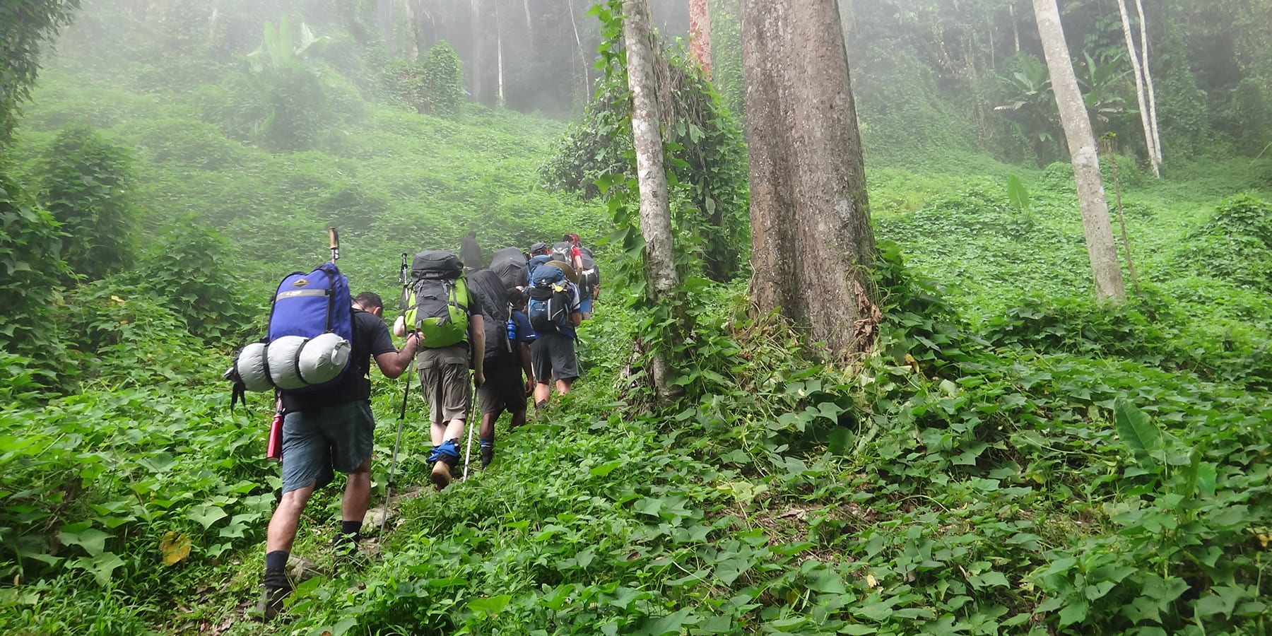
9. Kokoda Track, Papua New Guinea
Distance: 96 km (60 miles)
Duration: 4-12 days
Primary Hazards: Tropical diseases, remoteness, extreme weather, rugged terrain
The Kokoda Track is as much a historical pilgrimage as it is a hiking challenge. This jungle trail follows the route of a crucial World War II battle between Australian and Japanese forces. Today, it's a muddy, steamy, brutally difficult trek through some of the world's most challenging terrain.
Why It's Deadly:
The trail crosses the Owen Stanley Range, requiring hikers to repeatedly climb and descend steep mountain ridges in tropical heat and humidity. The path is often knee-deep mud, streams must be crossed on logs or by wading, and the jungle harbors malaria-carrying mosquitoes and other tropical diseases.
Medical evacuation from remote sections can take 24-48 hours. Sprained ankles, heat exhaustion, and tropical infections are common. The high humidity prevents sweat from evaporating, making heat management extremely difficult.
Survival Tips:
- Get comprehensive vaccinations and antimalarial medication before departure
- Hire experienced local guides they know the trail and can provide cultural context
- Pack extensive first-aid supplies including antibiotics
- Bring at least three changes of clothing that dry quickly
- Use gaiters to prevent leeches from attaching
- Start training months in advance; focus on leg strength and stair climbing
- Expect to be wet and muddy for days mental preparation is crucial
8. Half Dome Cables, Yosemite National Park, California, USA
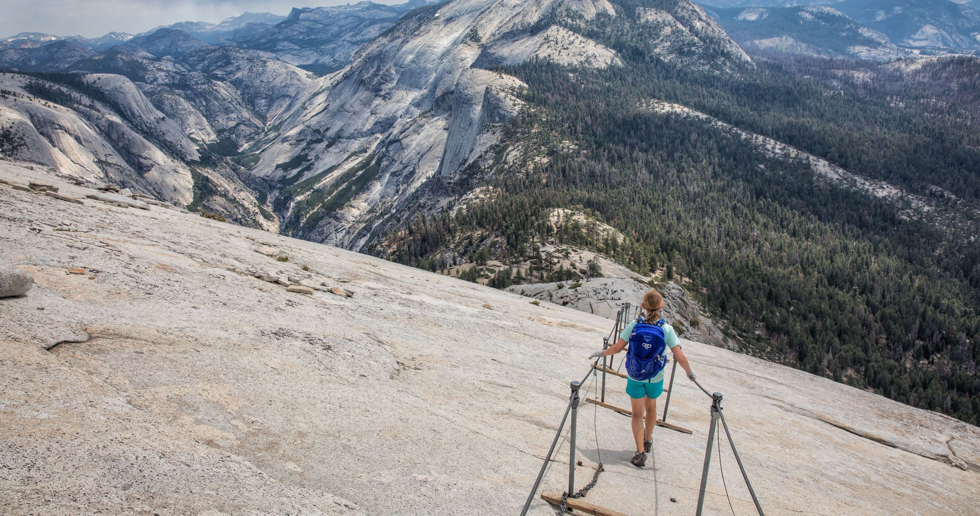
Elevation Gain: 1,463 meters (4,800 feet)
Death Toll: 20+ documented deaths on the cables
Primary Hazards: Lightning strikes, falls from cables, overcrowding
Half Dome is Yosemite's most iconic feature, and the cable route to its summit is one of America's most famous and dangerous day hikes. The final 122 meters (400 feet) requires pulling yourself up a 45-60 degree granite slope using cable handrails.
Why It's Deadly:
The smooth granite becomes incredibly slippery when wet. Afternoon thunderstorms are common in summer, turning the exposed dome into a lightning magnet several hikers have been killed by lightning strikes. The cables are also dangerously overcrowded on popular days, with lines of hikers waiting to ascend or descend, creating bottlenecks where tired, nervous hikers freeze up or make mistakes.
Even on dry days, exhausted hikers on the descent lose their grip or footing and slide down the granite. Unlike a trail fall where you might tumble a few feet, falling from the cables means sliding hundreds of feet down unforgiving rock.
Survival Tips:
- Start before dawn to avoid afternoon thunderstorms and crowds
- Get a permit—they're required and limited for good reason
- Bring gloves to protect your hands on the cables
- Descend backward, facing uphill, for better control and visibility
- If a storm approaches while you're on the cables, descend immediately don't wait
- Use a carabiner and safety tether to clip onto the cables (not standard, but recommended)
- Know your limits; there's no shame in turning back before the cables
7. Huayna Picchu, Peru
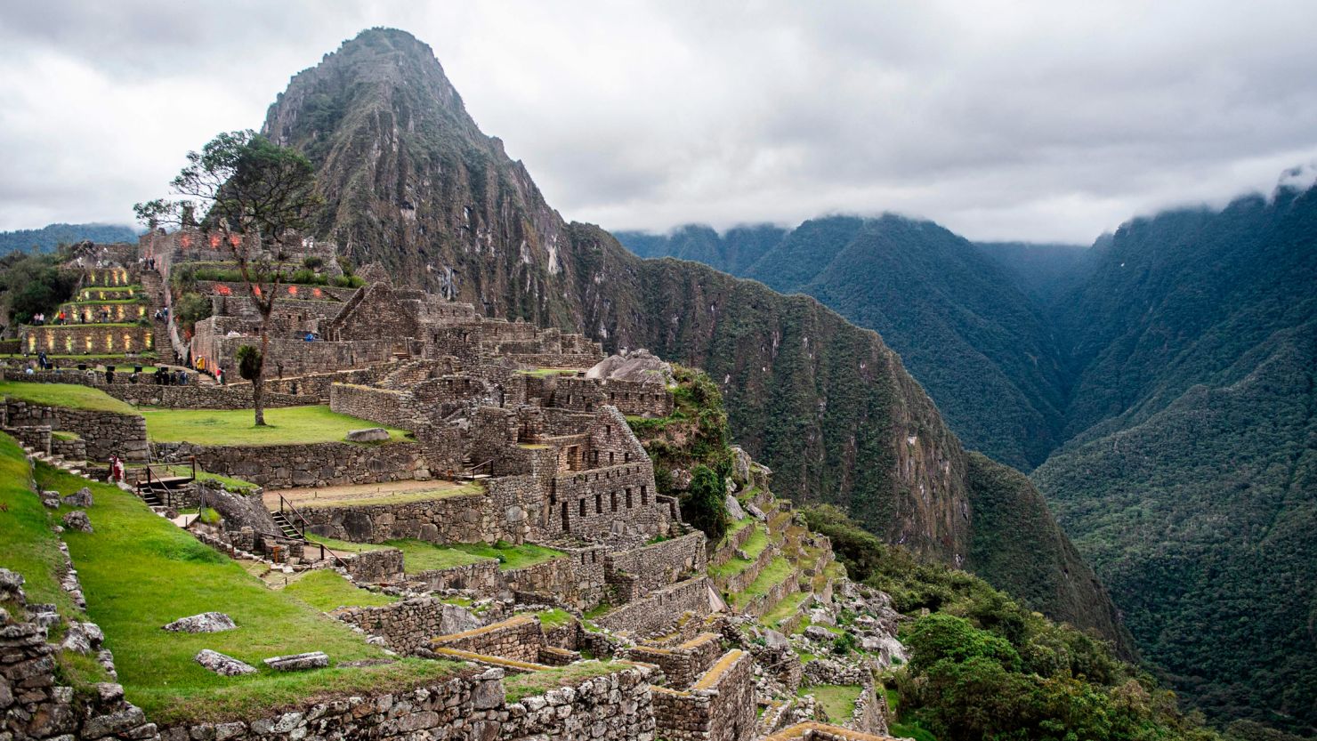
Elevation: 2,693 meters (8,835 feet)
Death Toll: Multiple falls annually
Primary Hazards: Narrow stairs, steep drops, slippery conditions, altitude
Rising behind the famous ruins of Machu Picchu, Huayna Picchu offers stunning views and death-defying Inca staircases. This peak appears in the background of classic Machu Picchu photos, tempting visitors to climb it without understanding the danger.
Why It's Deadly:
The trail follows ancient Inca stone steps—many just 30 centimeters (12 inches) wide carved into near-vertical cliff faces. Some sections feature drops of over 600 meters (2,000 feet) with no railings or protection. The stones are worn smooth and become treacherous when wet (which is often, given the cloud forest location).
The stairs known as the "Stairs of Death" live up to their name. They're nearly vertical, with no handrails, requiring hikers to use their hands as much as their feet. Several people fall from this trail each year, and rescue is extremely difficult given the terrain.
Survival Tips:
- Book your permit well in advance only 400 people per day are allowed
- Go early in the morning for better weather and fewer crowds
- Wear hiking boots with excellent grip; trail runners or tennis shoes are inadequate
- Use hiking poles for additional stability on descent
- Take your time rushing causes accidents
- If you have a fear of heights or poor balance, skip this hike
- The altitude at Machu Picchu is real spend a day acclimatizing first
6. Mount Hua (Huashan), China
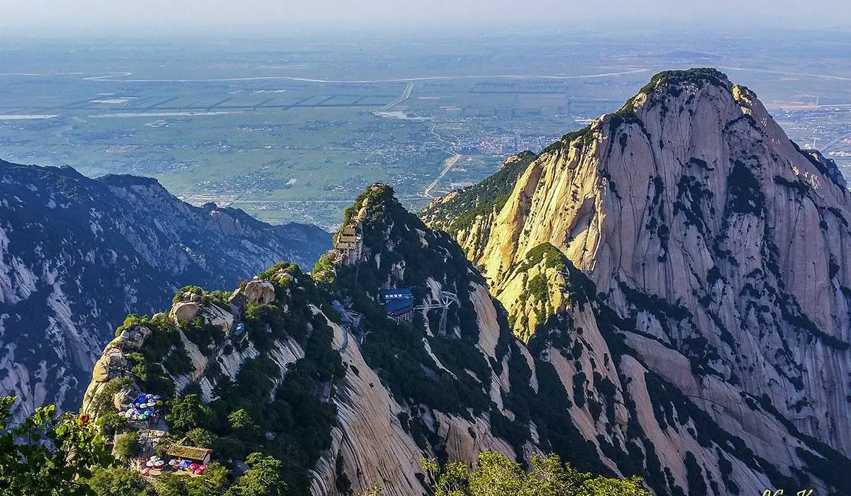
Elevation: 2,154 meters (7,070 feet)
Death Toll: Estimated 100+ deaths annually (unofficial)
Primary Hazards: Plank walk, chains on vertical cliffs, overcrowding
Mount Hua features what might be the world's most terrifying hiking trail: the Plank Walk in the Sky. This trail consists of narrow wooden planks bolted to the side of a vertical cliff, with a chain to hold onto as your only safety measure. The drop below? Over 600 meters (2,000 feet) straight down.
Why It's Deadly:
The Chinese government doesn't release official death statistics, but local accounts suggest over 100 people die on Mount Hua each year. The mountain features multiple extremely dangerous sections: steep stone stairs (sometimes carved directly into vertical rock), chain-assisted climbing routes, and the infamous plank walk.
Safety harnesses are available but weren't always required, and even with them, accidents happen. The mountain's popularity means it's often crowded, creating dangerous bottlenecks on narrow sections where one person's mistake can affect multiple hikers.
Survival Tips:
- Visit on weekdays to avoid weekend crowds
- Always use the provided safety harness check it's properly secured before each section
- Avoid the plank walk if you have any fear of heights; there's no shame in it
- Don't attempt in rain or ice the chains and planks become death traps
- Wear gloves to protect your hands on the chains
- Stay focused; taking selfies on these trails has killed multiple people
- Consider taking the cable car up and walking down descending is often more dangerous
5. El Caminito del Rey, Spain
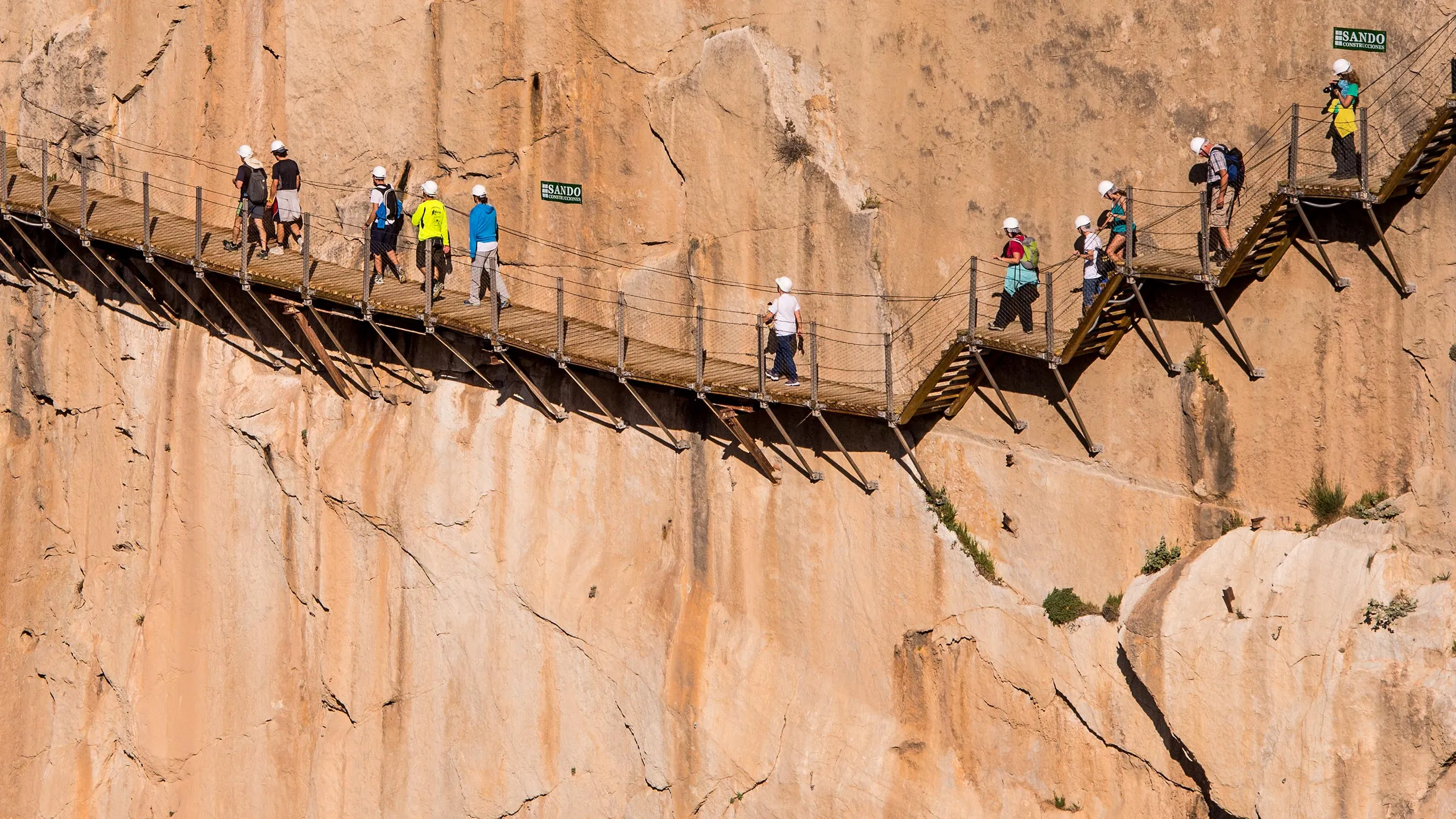
Length: 7.7 km (4.8 miles)
Historical Death Toll: 5+ documented deaths before restoration
Primary Hazards: (Historical) deteriorated walkways, falls from height
Known as "The King's Little Pathway," El Caminito del Rey was once considered the world's deadliest walking path. Built in 1905 for hydroelectric workers, by the 1990s it had deteriorated to the point where sections had completely collapsed, leaving only exposed rebar to walk on.
Why It Was Deadly:
The walkway is pinned to the side of a narrow gorge, 100 meters (330 feet) above the river. Before its 2015 restoration, the concrete had crumbled away, safety rails were gone, and hikers had to traverse gaps using rotting boards and prayer. Several fatal falls led to the path being officially closed, though thrill-seekers still attempted it.
Current Status & Survival Tips:
The good news: El Caminito del Rey was completely rebuilt and reopened in 2015 with modern walkways, proper railings, and safety measures. The restored version is now relatively safe, though still spectacular and not for those with severe vertigo.
- Book tickets online in advance they sell out quickly
- The modern route is one-way only; there's no turning back once you start
- Despite safety improvements, pay attention and respect the cliff exposure
- The walk takes 3-4 hours; bring water and sun protection
- This is now more of an exciting experience than a dangerous hike
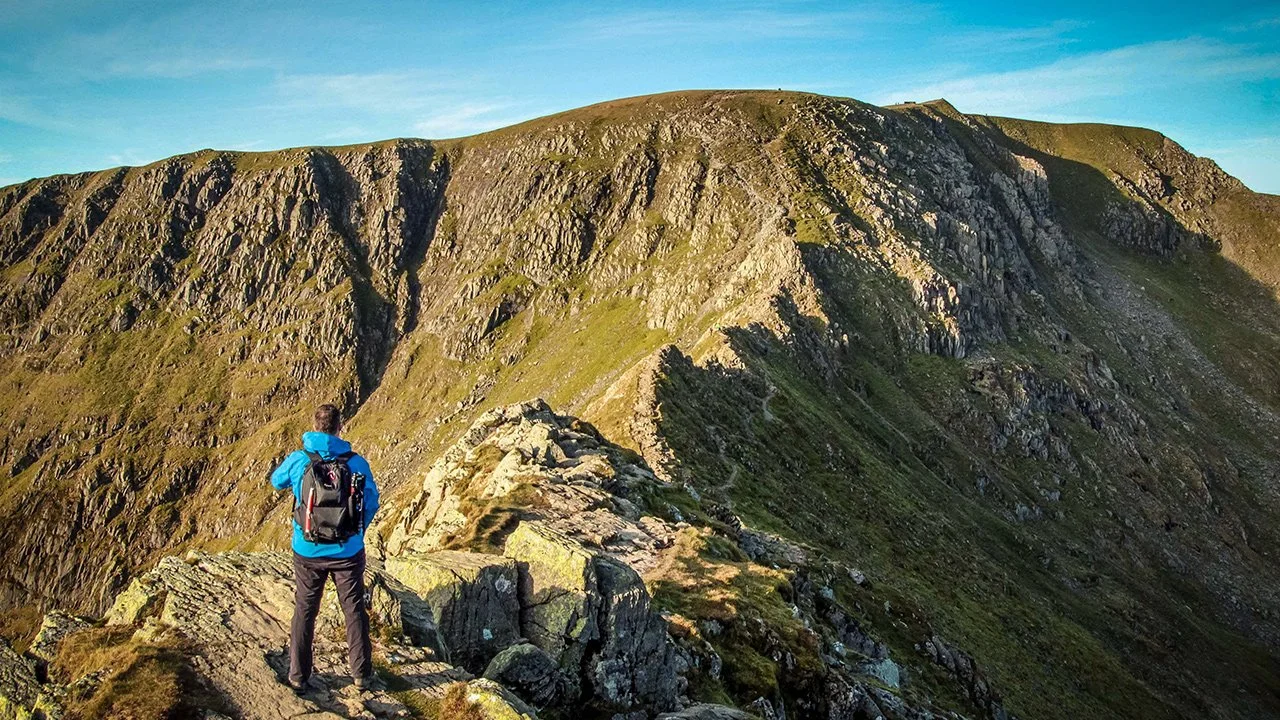
4. Striding Edge, Lake District, England
Elevation Gain: 584 meters (1,916 feet) to Helvellyn summit
Death Toll: Several deaths annually
Primary Hazards: Narrow arête, exposure on both sides, sudden weather changes
Don't be fooled by England's modest mountains Striding Edge has claimed lives regularly since Victorian times. This knife-edge ridge leads to the summit of Helvellyn and features a narrow rocky spine with dramatic drops on both sides.
Why It's Deadly:
The combination of exposure, loose rock, and notoriously unpredictable British weather creates a dangerous scenario. Mist can roll in within minutes, reducing visibility to a few meters. Rain makes the rocks slippery, and high winds can literally blow hikers off the narrow ridge.
The route requires scrambling skills and a head for heights. While technically a hiking route (not requiring ropes or technical gear), the psychological challenge of the exposure causes some hikers to freeze up, creating dangerous situations. Winter conditions transform it into a serious mountaineering route requiring crampons and ice axes.
Survival Tips:
- Check weather forecasts; avoid in high winds, rain, or low visibility
- Start early; the most common mistake is arriving late afternoon as weather deteriorates
- Don't attempt in winter conditions without mountaineering experience
- The path is reversible if you reach a section that seems beyond your skill level, turn back
- Study the route beforehand; YouTube videos can help you visualize the exposure
- Wear boots with good ankle support and grip
- Consider hiring a guide for your first attempt
3. Angels Landing, Zion National Park, Utah, USA
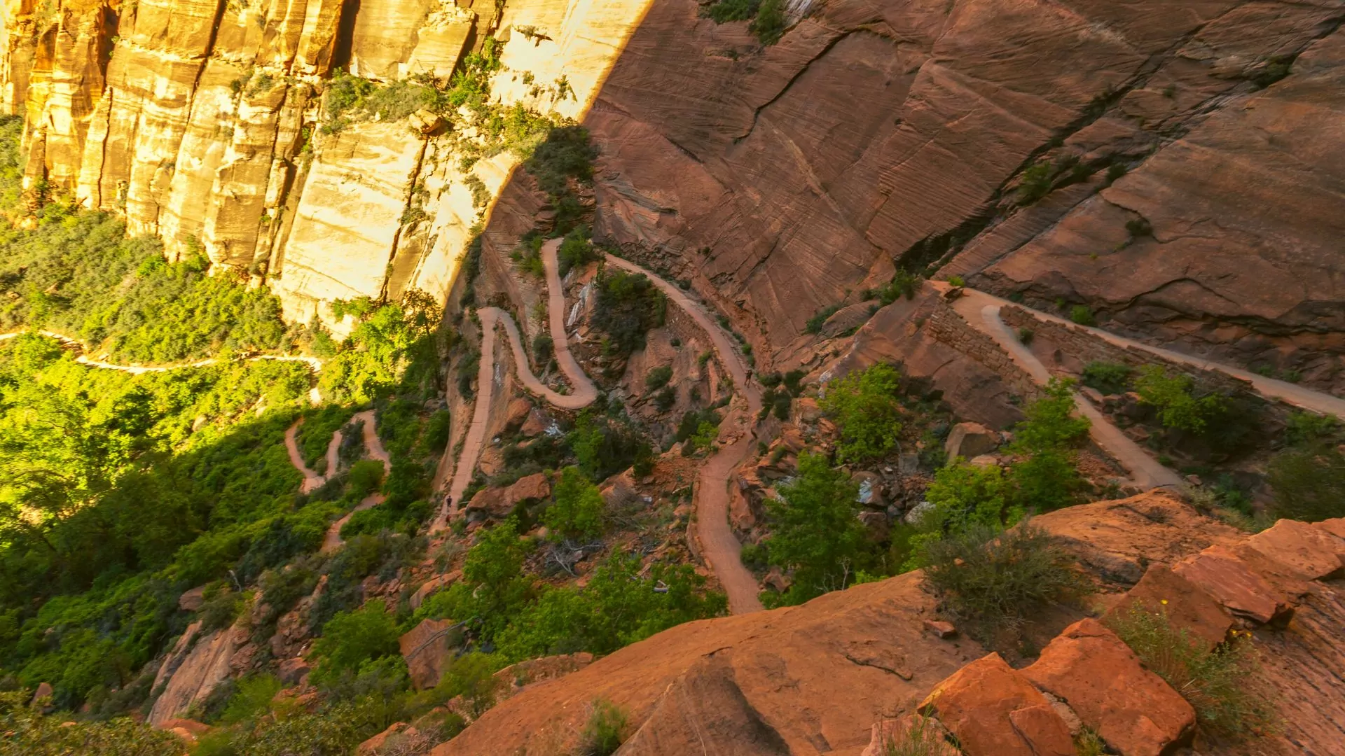
Elevation Gain: 453 meters (1,488 feet)
Death Toll: 14+ documented deaths since 2000
Primary Hazards: Narrow spine, sheer drops, chains, overcrowding
Angels Landing is one of America's most famous and fatal day hikes. The final half-mile follows a narrow rock fin with 1,000-foot drops on both sides, requiring hikers to pull themselves along using chains bolted into the rock.
Why It's Deadly:
The combination of exposure and crowds creates a perfect storm of danger. The final section is only 3-6 feet wide in places, with falls on either side that would be unsurvivable. When crowded (which is often), hikers must pass each other on this narrow spine, leading to accidents.
Deaths are usually from falls, though one person was struck by lightning. The wind can be intense on the exposed fin, and the smooth sandstone becomes treacherous when wet. Afternoon thunderstorms are common in summer, creating lightning hazards on the most exposed part of the trail.
Survival Tips:
- As of 2022, permits are required even for day hikes get one through the lottery system
- Start before sunrise to avoid crowds and afternoon storms
- Bring gloves to protect your hands on the chains
- Turn back if the chains are crowded waiting increases risk and exhaustion
- Skip this hike if you have any fear of heights or recent injuries
- The last person died in 2019 respect the danger
- There's an excellent view just before the chains section; that's still an accomplishment
2. The Snowman Trek, Bhutan
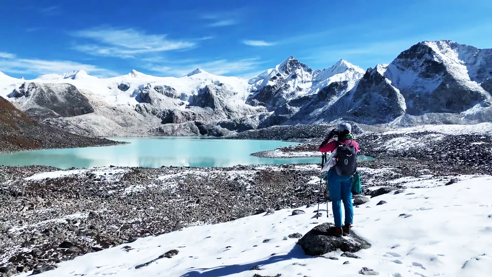
Distance: 300+ km (186 miles)
Duration: 25-30 days
Death Toll: Unknown (few attempt it)
Primary Hazards: Extreme altitude, avalanches, weather, remoteness
The Snowman Trek is considered by many to be the world's most difficult trek. This Bhutanese route crosses eleven mountain passes over 4,500 meters (14,800 feet), with three exceeding 5,000 meters (16,400 feet). Fewer than 2,000 people have attempted it, and less than half complete it.
Why It's Deadly:
The combination of extreme altitude, weather unpredictability, and utter remoteness makes this trek extraordinarily challenging. Altitude sickness is almost guaranteed, and there's no way to evacuate quickly if someone develops serious symptoms. The trek passes through territory so remote that villages are days apart.
Weather can change in moments, with blizzards possible even in the official trekking season. The high passes are vulnerable to avalanches. And because so few attempt it, the trail is often overgrown or hard to follow, even with guides.
Survival Tips:
- Expect to pay $200-300 per day Bhutan's mandatory daily fee includes guides, permits, and logistics
- Spend at least a week acclimatizing in Bhutan before starting
- Be prepared to turn back; most failures are due to altitude sickness, not lack of fitness
- Bring high-quality cold weather gear rated for -20°C (-4°F) or lower
- Physical training should include multi-day backpacking with significant elevation gain
- Mental preparation is crucial; this is a month-long expedition, not a hike
- Only attempt with experienced guides solo trekking is not allowed in Bhutan
1. Mount Everest via the Death Zone, Nepal/Tibet
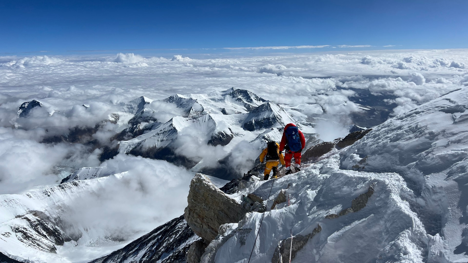
Elevation: 8,849 meters (29,032 feet)
Death Toll: 320+ documented deaths
Primary Hazards: Extreme altitude, the Death Zone, avalanches, crevasses, weather, overcrowding
Mount Everest needs no introduction. The world's highest peak above sea level represents the ultimate mountaineering challenge—and the ultimate in danger. While the overall death rate has decreased to 1-3% in recent years (down from 14.5% historically), the mountain has still claimed over 320 lives.
Why It's Deadly:
Above 8,000 meters (26,247 feet) lies the "Death Zone" an altitude where the human body literally cannot survive long-term. Your body begins dying, cell by cell. Most Everest deaths occur in the Death Zone, where oxygen levels are only 30% of those at sea level, temperatures drop below -60°C (-76°F), and winds can exceed 160 km/h (100 mph).
The bodies of over 200 climbers remain on the mountain, frozen in time, serving as grim waypoints for those attempting the summit. The most dangerous section is the final 300 meters the "longest mile on Earth" where exhausted climbers must navigate a steep, smooth rock face with minimal oxygen.
Common causes of death include avalanches, falls into crevasses, altitude sickness (HACE and HAPE), frostbite leading to death, and simply running out of energy in the Death Zone. The increasing commercialization has led to overcrowding, creating deadly bottlenecks where climbers must wait in the Death Zone while oxygen supplies dwindle.
Survival "Tips" (Acknowledging This Is Extreme Mountaineering, Not Hiking):
- Expect to spend $40,000-90,000 and two months on the expedition
- The climb itself takes about a month, with another month for acclimatization
- You'll likely lose 10-15 kg (22-33 lbs) during the ascent
- Cardiovascular fitness must be exceptional; altitude makes everything harder
- Consider using supplemental oxygen, despite purist objections—it saves lives
- Turn back if you're not at the summit by 1-2 PM; descending in darkness is deadly
- The mountain doesn't care about your summit dreams listen to your guides
- Many deaths occur during descent when exhaustion takes over—save energy for coming down
Essential Gear for Deadly Hikes
Proper gear can mean the difference between life and death on dangerous trails. While specific equipment varies by trail, here's what should be in every serious hiker's pack:
The Non-Negotiables
Navigation
- Physical topographic map (not just phone apps)
- Compass and knowledge of how to use it
- GPS device with pre-loaded trail maps
- Satellite messenger (Garmin inReach, SPOT) for areas without cell service
Emergency Shelter & Warmth
- Emergency bivy or space blanket
- Waterproof, windproof jacket and pants
- Insulating layers (even in summer for high elevations)
- Fire-starting supplies in waterproof container
Water & Filtration
- Minimum 3 liters water capacity
- Water filtration system or purification tablets
- Extra electrolyte packets
First Aid & Medical
- Comprehensive first aid kit
- Personal medications
- Altitude sickness medication (for high elevation trails)
- Blister treatment and prevention
- Ace bandage for sprains
- Pain relievers and anti-inflammatories
Communication & Rescue
- Fully charged satellite messenger
- Whistle (three blasts is international distress signal)
- Signal mirror
- Headlamp with extra batteries
Protection
- Sun protection: sunscreen (SPF 50+), lip balm, sunglasses, hat
- Gloves (for chains and cold weather)
- Gaiters (for snow, mud, and stream crossings)
- Hiking poles (absolutely essential for steep descents)
The Often-Forgotten Essentials
- Repair kit: Duct tape, cable ties, safety pins
- Nutrition: High-calorie emergency food beyond your planned meals
- Cash: For emergency situations where electronic payment won't work
- Permit copies: Keep them waterproofed
- Emergency contact info: Written down, not just in your phone
Training for Deadly Hikes
Showing up to a dangerous trail without proper preparation is essentially gambling with your life. These trails demand both physical fitness and mental fortitude.
Physical Training Protocol (3-6 Months Before)
Cardiovascular Conditioning
- Build to 5+ hours of continuous hiking per week
- Include elevation gain in your training stairs, hills, or treadmill incline
- Practice carrying a weighted pack (add 10-15% of your body weight)
Strength Training
- Focus on legs: squats, lunges, step-ups
- Core strength: planks, mountain climbers, Russian twists
- Upper body: Important for climbs requiring chains or hands-on scrambling
Balance and Coordination
- Practice on uneven terrain
- Balance exercises: single-leg squats, wobble board work
- Yoga for flexibility and body awareness
Altitude Acclimatization (for high-elevation trails)
- Spend nights at progressively higher elevations before your trek
- Consider using altitude training masks (limited effectiveness)
- Learn to recognize altitude sickness symptoms in yourself
Mental Preparation
Physical fitness alone won't get you through a deadly trail. Mental preparation is equally crucial:
Visualization
- Study trail videos and photos
- Mentally rehearse exposed sections
- Visualize yourself calmly handling difficult situations
Fear Management
- Acknowledge your fear it's keeping you alert
- Practice controlled breathing techniques
- Know the difference between healthy caution and panic
Decision-Making Under Stress
- Set turnaround times before you start
- Make the decision to turn back easier by celebrating "good decisions" not just summits
- Practice decision-making under fatigue during training hikes
Suffering Management
- Long training hikes teach you to function while uncomfortable
- Practice positive self-talk during difficult moments
- Remember: discomfort is temporary; injury or death is permanent
Weather Wisdom
Weather is the invisible killer on many deadly trails. Here's how to read conditions and make smart decisions:
Pre-Trip Weather Research
More Than Just the 10-Day Forecast
- Research the trail's typical weather patterns for your planned dates
- Understand the microclimate mountains create their own weather
- Check historical weather data for the specific location
- Monitor mountain-specific weather services (like Mount Washington Observatory)
Red Flags to Postpone
- Forecast of storms during your summit day
- Unusual weather patterns (warm temps bringing avalanche risk, etc.)
- High wind warnings for exposed ridges
- Winter storms for trails that become impassable
On-Trail Weather Assessment
Cloud Reading 101
- Lenticular clouds over peaks: High winds aloft, storms likely
- Rapidly building cumulus towers: Afternoon thunderstorms forming
- Dark clouds approaching: Turn back, don't wait to feel rain
- Cloud base dropping: Weather deteriorating fast
Wind Signs
- Trees swaying or bending: Winds too strong for exposed ridges
- Difficulty hearing your partner: Winds dangerous for balance
- Dust or snow creating ground blizzards: Visibility about to drop
Temperature Drops
- A sudden temp drop often precedes a storm front
- If you're warm and suddenly chilled, weather is changing
- Wind chill can drop temperatures 20-30 degrees
The Turn-Back Decision
This is the hardest decision you'll make on a dangerous trail, but it's often the most important:
Turn back if:
- Weather is deteriorating faster than forecast
- Lightning is visible or thunder heard (you're already in danger)
- Group members showing signs of altitude sickness, hypothermia, or exhaustion
- You're behind schedule and will be caught in darkness or weather
- Your gut says something is wrong trust your instincts
Remember: The mountain will always be there. You might not be if you push on.
Altitude Sickness
Acute Mountain Sickness (AMS) and its severe forms High Altitude Pulmonary Edema (HAPE) and High Altitude Cerebral Edema (HACE) kill experienced mountaineers every year. Understanding and recognizing these conditions is crucial for any high-elevation hike.
Understanding Altitude Sickness
Above 2,500 meters (8,200 feet), the air contains less oxygen. Your body must work harder to get the oxygen it needs. If you ascend too quickly, your body can't adapt fast enough, leading to altitude sickness.
Mild Altitude Sickness (AMS) Symptoms:
- Headache (often feels like a hangover)
- Nausea and loss of appetite
- Dizziness or lightheadedness
- Fatigue and weakness
- Difficulty sleeping
Severe Altitude Sickness (HAPE/HACE) Symptoms:
- Severe headache that doesn't respond to medication
- Vomiting
- Confusion or irrational behavior
- Loss of coordination (ataxia)
- Severe shortness of breath even at rest
- Bubbling or rattling sound in chest
- Blue lips or fingernails (cyanosis)
Prevention Strategies
The Golden Rules:
- Ascend slowly "climb high, sleep low"
- Don't increase sleeping elevation by more than 300-500m (1,000-1,600 ft) per day above 3,000m
- Build in acclimatization days every 1,000m of elevation gain
- Stay hydrated drink enough that your urine is clear or light yellow
- Avoid alcohol and sleeping pills at altitude
Medication Options:
- Acetazolamide (Diamox): Speeds acclimatization, prevents AMS
- Dexamethasone: For severe symptoms, emergency treatment only
- Ibuprofen: May help prevent altitude headaches
- Consult your doctor before taking any altitude medication
Treatment Protocol
For Mild AMS:
- Stop ascending; stay at current altitude until symptoms improve
- Rest, hydrate, eat light meals
- Take over-the-counter pain relievers for headache
- Consider acetazolamide if not already taking it
For Severe Symptoms (HAPE/HACE):
- DESCEND IMMEDIATELY this is the only definitive treatment
- Administer oxygen if available
- Give dexamethasone
- Descend at least 500-1,000 meters (1,600-3,300 feet)
- Seek medical help as soon as possible
Critical Warning: If someone shows signs of HACE (confusion, ataxia) or HAPE (severe breathing difficulty), they are dying. Descending is not optional it's the only way to save their life. Don't wait until morning. Don't hope they'll improve with rest. Descend now.
Emergency Protocols
Despite perfect preparation, emergencies happen on dangerous trails. Knowing how to respond can save lives.
The STOP Protocol
When something goes wrong, panic is your enemy. Use the STOP protocol:
S - Stop
Stop moving. Panicked movement often makes situations worse.
T - Think
Assess the situation calmly. What exactly is wrong? What are your options?
O - Observe
Look around. Where are you? What resources do you have? What are the hazards?
P - Plan
Develop a plan of action before moving forward.
Common Emergency Scenarios
Scenario 1: Someone Falls and Is Injured
- Ensure your own safety first you can't help if you fall too
- Reach the injured person if safe to do so
- Assess injuries: life-threatening bleeding? Head injury? Broken bones?
- Treat what you can with first aid kit
- Activate emergency beacon/satellite messenger
- Keep injured person warm and comfortable
- Document exact location (GPS coordinates)
- If rescue will take hours, consider whether moving the person is safer than staying
Scenario 2: Lost or Off-Trail
- Stop immediately—don't wander further
- Try to retrace your steps to last known position
- If unable to find trail, stay put if you have shelter and supplies
- Make yourself visible: bright clothing, signal mirror, whistle
- Follow the drainage downhill only as last resort (can lead to cliffs)
- Activate emergency beacon if unable to navigate back
Scenario 3: Sudden Weather Emergency
- Seek immediate shelter even partial shelter is better than exposure
- Put on all insulating and waterproof layers
- Get off exposed ridges and peaks (lightning risk)
- If above treeline, crouch low but don't lie flat
- Wait out the storm if possible
- If hypothermia symptoms appear, activate emergency beacon immediately
Scenario 4: Altitude Sickness
- Stop ascending immediately
- Rest and hydrate
- Take altitude sickness medication if available
- If symptoms worsen or don't improve, descend immediately
- If severe symptoms (confusion, difficulty breathing), treat as life-threatening emergency
International Distress Signals
- Three of anything: Three whistle blasts, three flashes of light, three fires, three anything = distress
- Six blasts/flashes per minute: Alpine distress signal
- Ground to air signals:
- X = Need medical assistance
- V = Need assistance
- N = No/negative
- Y = Yes/affirmative
Legal and Ethical Considerations
Permits and Regulations
Many dangerous trails now require permits to limit overcrowding and improve safety. Don't skip this step:
- Angels Landing: Permit required even for day hikes (lottery system)
- Half Dome: Permit required via lottery
- Huayna Picchu: Only 400 permits per day, book months ahead
- Mount Everest: Climbing permit costs $11,000+ per person
- Various trails in national parks worldwide: Check specific requirements
Leave No Trace Principles
Even on deadly trails, environmental responsibility matters:
- Pack out all trash (including toilet paper)
- Stay on established trails to prevent erosion
- Camp only in designated areas
- Respect wildlife you're in their home
- Leave what you find (rocks, plants, artifacts)
Rescue Costs
Many regions will charge for rescue operations, especially if negligence was involved:
- Europe: Mountain rescue can cost €5,000-20,000
- United States: Some states charge for rescues, others don't
- Nepal/Tibet: Helicopter rescue from Everest costs $10,000-40,000+
Mountain rescue insurance is available and strongly recommended for any trip to remote or high-risk areas.
The Psychology of Risk
After reading about all these dangers, you might wonder: Why do people do this? What drives someone to risk their life on a narrow mountain path or in the Death Zone?
The Motivations
Personal Challenge
For many, these trails represent the ultimate test of their abilities. Completing a deadly hike proves something to themselves—that they have the skill, courage, and determination to succeed where others fail.
Connection with Nature
There's something primal about standing on a knife-edge ridge or navigating a remote wilderness. These experiences connect us with nature in ways impossible in everyday life.
The View
Sometimes, literally. The views from these dangerous places are often the most spectacular on Earth, accessible only to those willing to take the risk.
Achievement and Bragging Rights
Let's be honest: There's a social aspect. Completing a famous dangerous trail gives you a story to tell and a sense of accomplishment that few can claim.
The Presence of Death
Paradoxically, confronting danger makes us feel more alive. In these moments, we're fully present, fully aware, experiencing life at its most intense.
The Risks of "Summit Fever"
"Summit fever" is a dangerous psychological state where the desire to reach the summit overrides good judgment. It's killed countless mountaineers who pushed on despite:
- Deteriorating weather
- Running low on oxygen or supplies
- Being behind schedule
- Showing altitude sickness symptoms
- Clear signs they should turn back
Combating Summit Fever:
- Set turn-around times before you start and stick to them
- Remember: Reaching the summit is optional; getting down safely is mandatory
- Celebrate good decisions as victories, not just summits
- Remove ego from the equation turning back is often braver than pushing on
Trail-Specific Quick Reference Guide
Here's a quick-reference chart comparing the deadliest hikes:
| Trail | Location | Difficulty Level | Technical Skills Required | Best Season | Approximate Duration |
|---|---|---|---|---|---|
| Mount Washington | USA (NH) | Moderate | Basic hiking | Jun-Sep | 1 day |
| Kalalau Trail | USA (HI) | Moderate-Difficult | Basic hiking, stream crossings | May-Sep | 2-3 days |
| The Maze | USA (UT) | Difficult | Navigation, desert survival | Mar-May, Sep-Nov | 3-7 days |
| Kokoda Track | Papua New Guinea | Very Difficult | Jungle trekking | Apr-Nov | 4-12 days |
| Half Dome Cables | USA (CA) | Difficult | Scrambling, cables | May-Oct | 1 day |
| Huayna Picchu | Peru | Moderate-Difficult | Exposed stairs | May-Oct | 3-4 hours |
| Mount Hua | China | Difficult | Via ferrata skills | Apr-Oct | 1-2 days |
| El Caminito del Rey | Spain | Moderate (post-restoration) | Basic hiking | Year-round | 3-4 hours |
| Striding Edge | England | Difficult | Scrambling | May-Oct | 5-8 hours |
| Angels Landing | USA (UT) | Difficult | Exposed chains, scrambling | Apr-Oct | 4-6 hours |
| Snowman Trek | Bhutan | Extreme | High-altitude trekking | Sep-Oct | 25-30 days |
| Mount Everest | Nepal/Tibet | Extreme | Mountaineering | Apr-May, Sep-Oct | 60+ days |
Respect the Mountain, Respect Yourself
The world's deadliest hikes offer something that sanitized, safe experiences cannot: the opportunity to test ourselves against nature at its most raw and unforgiving. These trails have earned their reputations through tragedy, triumph, and the countless stories of those who've walked them.
But here's the uncomfortable truth: Most deaths on these trails are preventable. They result from overconfidence, poor preparation, bad decision-making, or simple bad luck. The mountains don't actively try to kill you they're indifferent to your existence. It's your responsibility to respect their power and your limitations.
The Final Checklist
Before you attempt any dangerous trail, honestly answer these questions:
- [ ] Do I have the technical skills required?
- [ ] Have I trained adequately for the physical demands?
- [ ] Do I have proper gear and emergency equipment?
- [ ] Have I researched the trail thoroughly?
- [ ] Do I understand the weather patterns and risks?
- [ ] Have I obtained necessary permits?
- [ ] Have I informed someone of my plans and expected return?
- [ ] Am I mentally prepared to turn back if conditions warrant it?
- [ ] Do I have proper insurance, including rescue coverage?
- [ ] Am I doing this for the right reasons, or am I giving in to external pressure?
If you can't honestly check every box, delay your trip. The mountain will wait.
The Beauty in the Beast
Despite all the warnings, dangers, and gruesome statistics, these trails continue to call to adventurers worldwide. Why? Because conquering fear, testing limits, and experiencing raw nature is part of what makes us human. The challenge is doing so responsibly, with proper respect for both the mountain and your own mortality.
The mountains teach humility. They teach respect. They teach that nature doesn't care about your Instagram followers, your bucket list, or your need to prove something. But for those who approach them properly prepared, with respect and caution, they offer experiences and memories that will last a lifetime.
Just make sure you're around to remember them.
Additional Resources
Essential Reading
- "Into Thin Air" by Jon Krakauer
- "The Climb" by Anatoli Boukreev
- "Not Without Peril" by Nicholas Howe
- "Mountaineering: The Freedom of the Hills" (9th Edition)
Training Resources
- National Outdoor Leadership School (NOLS)
- American Alpine Club courses
- Local mountaineering clubs and organizations
- REI Outdoor School
Weather & Conditions
- Mountain-Forecast.com
- National Weather Service Mountain Weather
- Local park-specific weather stations
- NOAA Aviation Weather for high-altitude conditions
Emergency Services
- Local search and rescue organizations
- International SOS for global coverage
- Your country's embassy for international travel
Remember: The best summit photo is the one where everyone makes it home.
Stay safe out there.
Have you hiked any of these deadly trails? Share your experience, survival tips, or close calls in the comments below. Your story might save someone's life.
Disclaimer: This article is for informational purposes only. Attempting any dangerous hike is done entirely at your own risk. Always consult with professionals, obtain proper training, and ensure you have the necessary skills and equipment before attempting any trail described here. The author and publisher assume no liability for accidents, injuries, or deaths resulting from attempting these hikes.